Alert
This trail is not maintained between November 1 and April 30.
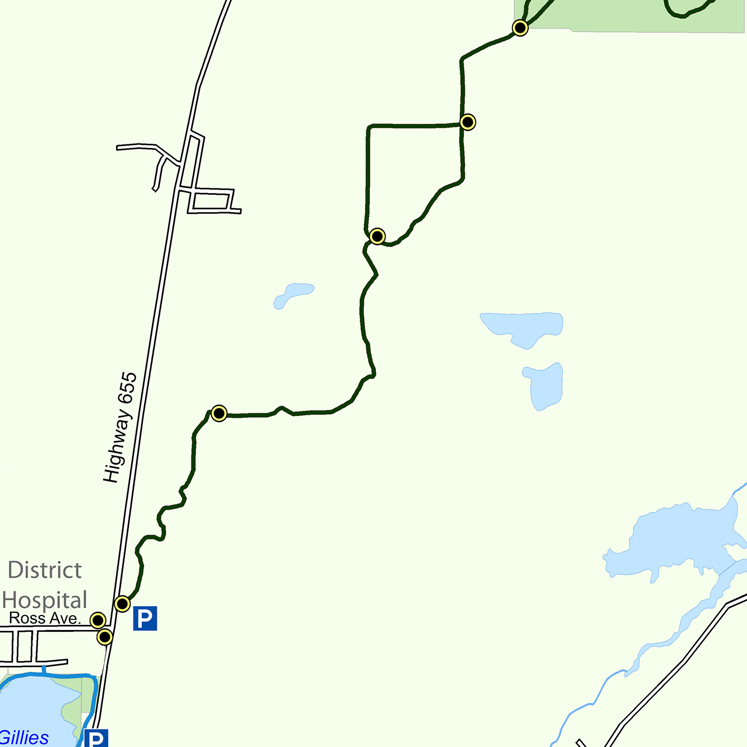
The Golden Springs Trail, named after the natural springs located just south of the Hersey Lake Conservation Area, was the first section of trail completed by the Trails Committee. Built in 1979, the trail links the Gillies Lake Promenade with the Hersey Lake area. It is constructed of a hard packed crushed rock material with several lookouts, rest areas and boardwalks located along its length. The Golden Springs Trail takes you through a gently rolling terrain complete with upland and lowland forests, bogs and many beautiful lakes.
Trail Description
The trailhead is located on the east side of Hwy 655 at the corner of Ross Avenue. A round trip to the Hersey Lake Conservation Area is 11.5 km while Rainbow Lake is just over 15 km. The first leg will take you northward along several old bush roads and trails, through some abandoned mine tailings areas and upland forests until you reach the Sand Claims Road Crossing. From here you travel east to the top of a man-made dike. The trail heads due north to McIntyre Flats where it forks into a west route and an east route. After about 0.5 km both routes join up again at the Jack Rabbit Circle. Continuing due north, the trail then passes through the Kestrel Crossroads. At this point, you can either take the more direct South Trail into the Hersey Lake Conservation Area, or continue on the Golden Springs Trail to the north. From here onwards the trail system is largely forested and contained within the conservation area’s boundaries. The many trails within the conservation area are laid out so that one is able to mix and match various trail loops while visiting the four corners of the park. Major intersections such as Wintergreen Circle, Raven Roundabout and Fisher Lake Square, all provide the trail user with directional signs and distances. The two major loops are the perimeter trail around the conservation area that visits Lynx Lake and Fisher Lake, and the north loop that goes to Rainbow Lake and back.
Highlights
- The trailhead marker post is located on the original shoreline of Gillies Lake before the lake was filled in with mine tailings back in the 1920’s and 1930’s. Gillies Lake, now only 22 hectares in area, was four times its present size and stretched to the northeast where it flowed into the Porcupine River.
- Sand Claims Road Crossing is really an old right-of-way once used for an aerial bucket line that brought sand and gravel from an area several kilometres to the north down to the Hollinger and McIntyre mines. This material was used to backfill the tunnels and stopes where gold ore had been removed.
- When the original trail was constructed in 1979, McIntyre Flats was covered by mature forest. that changed in 1981 when hundreds of hectares of land where clearcut. However, the area has rejuvenated naturally and is now well on its way to becoming a fully grown forest once again.
- A large area to the east of Jack Rabbit Circle has been used for the disposal of mine tailing, the pulverized waste rock that is left over after the gold ore has been processed. These ‘dams’ are prominent throughout the community.
- Kestrel Corners marks the southerly limit of the Hersey Lake Conservation Area, a park area set aside by the community for conservation and outdoor education. The area provides a natural oasis of trees, lakes, plants and animals for visitors to enjoy without having to travel too far from home. Further along the trail you arrive at the original Golden Springs, a natural spring fed by the groundwater held in the sand and gravels of the surrounding area. During dry summers, the springs will dry up almost completely while during the wetter ones, the springs will rejuvenate and provide habitat for ducks and aquatic animals.
- After passing Chickadee Corners, the trail again splits at Wintergreen Circle. At this point, you can head to the main beach at Hersey Lake or continue on to the north. At Hersey Lake there are many facilities including an extensive beach, washrooms,a picnic shelter and the self-guided interpretive Tamarack Trail. If you continue on you come to the Grouse Point Lookout. Here you get a full panoramic view looking towards the northwest. Most noticeable is the large sand and gravel pit. As mentioned earlier, this is where the aerial bucket line started its delivery of sand and gravel for the Hollinger and McIntyre mines.
- At Junco Junction, you must again make a choice. if you head directly north you will end up at Rainbow Lake where you will have an opportunity to visit a very picturesque northern lake complete with a viewing platform and benches. If you travel due east you will arrive at Jack Pine Lake Lookout, a typical bog lake with many unique plants, trees and animals. Turn due south and you will arrive back at Hersey Lake.
- Lynx Lake Circle is located deep within the forests of the Conservation Area. It is set aside as a satellite facility for our outdoor programs and includes washrooms, picnic tables , a wading beach and restricted parking. It sits on the boundary between the sandy upland forests of the conservation area and the low lying black spruce swamps.
- Once you reach Fisher Lake Square, you will be only a few steps away from one of the conservation area’s many jewels, Fisher Lake. A boardwalk will take you right to the water’s edge where you can marvel at the beauty of this small lake. In the fall, the tamarack that surround the lake turn a magnificent golden yellow.
- the Raven Roundabout is the last post before the trail loops back onto itself and marks the original road into the conservation area. At this point you can head north if you want to get back to the amin beach or head due south and make your way back to the Kestrel Crossroads. continuing on, you will reach the main trail at chickadee Corners.
Trail Maps
Georeferenced maps are available to download on our trail maps page. Pocket maps are available at the MRCA office.