Alert
This trail is not maintained between November 1 and April 30.
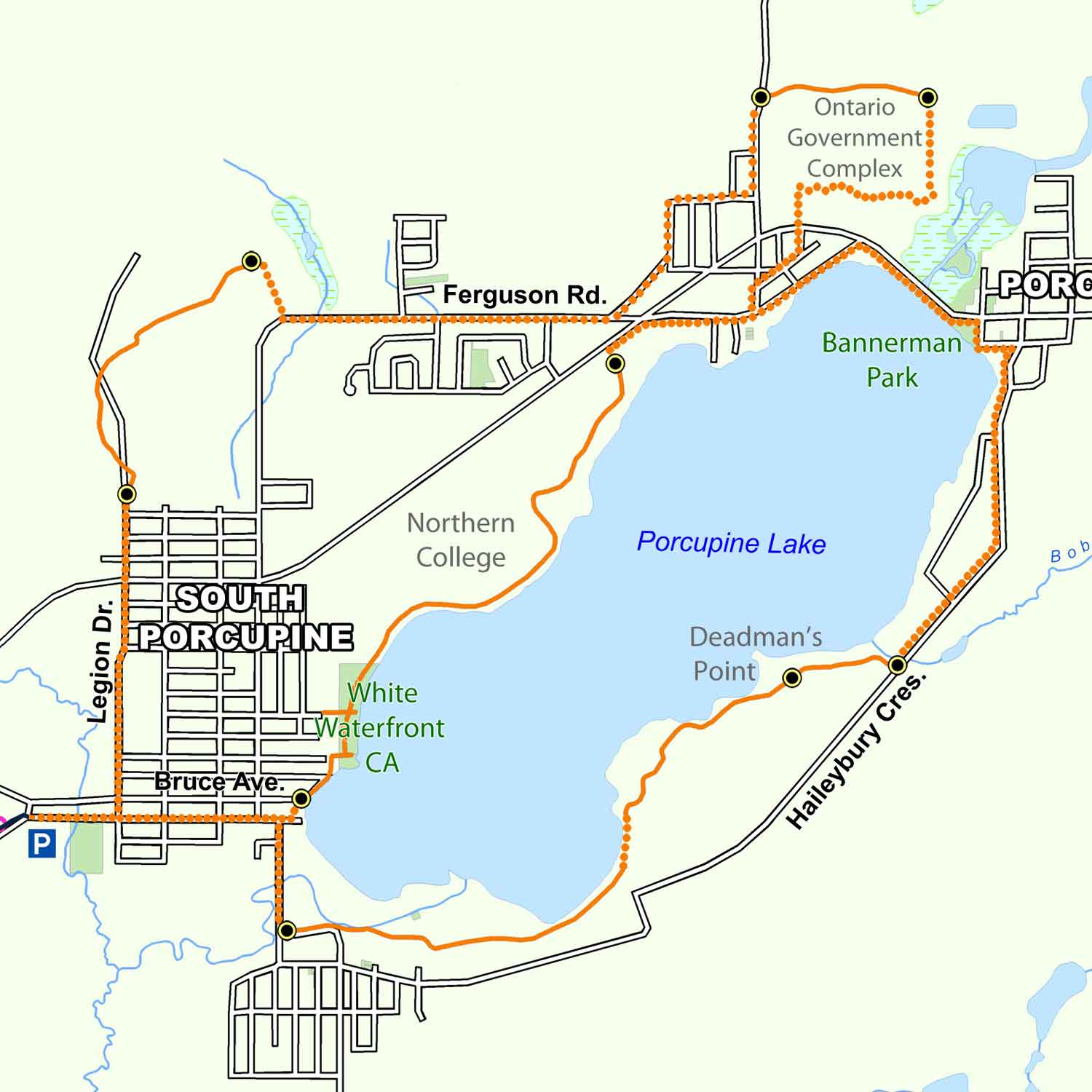
The second phase of the community trail system was started in 1980 with the completion of the Bart Thomson Trail, encompassing the shoreline of Porcupine Lake and an area to the north of Porcupine and South Porcupine. Named after one of the founding members of the Trails Committee, the Bart Thomson trail accesses the shoreline of Porcupine Lake at several locations. Here one can take some time and observe waterfowl, beavers and muskrat, as well as a great variety of land and water plants. The northerly half of the trail takes you through both lowland and upland forests, past interesting geological formations and several small streams and ponds.
Trail Description
The best starting off point for the Bart Thomson Trail is the Airport Hotel near the White Waterfront Conservation Area. In a counter clockwise direction around the lake, the south loop travels to the south along Evans Street to the old railway station at Connaught Hill. Turning due east, the trail goes through a marshy area until it emerges next to ONR right-of-way. From here it continues east across Goldrush Street, along the shores of Porcupine Lake, through Deadman’s Point cemetery until it meets up with Haileybury Crescent at Bob’s Creek. One has to use municipal roads (Haileybury Cres-Dixon St.) from here until you get to Bannerman Park. A separate walkway will take you across the Porcupine River to Bristol Road. Follow this road to the west, just past an old Ministry of Natural Resources Airbase. From here, head towards the lake where you can once again pick up the graveled trail. This will take you in behind the Whitney Arena, through the Northern College property, across the Crawford Creek channel until you are once again in the White Waterfront Conservation Area.
The north loop proceeds westward along Golden Avenue and then north on Legion Drive. At the end of Legion Drive just past the OPP Building the trail enters the forest continuing in a northerly direction. Here the trail goes through an uplands forest and many bedrock outcrops. Upon reaching the Davidson Road South marker, municipal roads (Davidson Rd.-Ferguson Rd.-Rekela St. N.-Division St.-Florence St.) can be used to reconnect with the trail at Florence Street. From here the trail passes through Ontario Government Complex where it joins up with their main service road at Shallow Lake. Looping around to the south, the trail brings you to Highway 101 and Bristol Road. At this point you cross the highway so that the southern portion of the trail can take you back to the Conservation Area and the Airport Hotel at the west end of the lake. The two loops that make up the Bart Thomson trail feature rest stops, lookouts and several historical and natural points of interest such as abandoned mines, geological formations and unique plants and animals. The section of trail between Northern College and White Waterfront is lit.
Highlights-South Loop
- The White Waterfront Conservation Area and Kinsmen Park, with their large, green open spaces, playground and picnic facilities, lookouts and beautiful shoreline, is considered the focus of the Bart Thomson Trail. Developed in the 1980’s by the Conservation Authority, the City and the Porcupine Kinsmen, the area is almost entirely flood plain and was once used for farming and as an air base. Along the shoreline you can observe the many birds and animals that inhabit the shores of Porcupine Lake.
- Along Evans Street you will notice that much of the land is vacant. This is as a result of the Conservation Authority acquiring and demolishing several homes and businesses that were subject to constant flooding from Porcupine Lake. In fact, walking the trail in the spring and early summer in certain years can be tricky because of high water. Almost the entire southern loop of the Bart Thomson Trail makes use of flood plain land.
- As you move along the south shore of the lake you will come upon many interesting features. These include the original South Porcupine train station on Railway Street, since converted to a residence, the abandoned ONR right-of-way, and the Dome Pump House used to draw water from the lake to feed the operations at the Dome mine. You will also see Deadman’s Point, one of the first mining camps in the area that later became a burial ground for the victims of the Great Porcupine Fire of 1911.
- Once you leave the bush and cross Bob’s Creek, the trail follows the Back Road until you reach Bannerman Park at the east end of Porcupine Lake. This park, which has a swimming beach and boat launch, is named after George Bannerman, a prospector who staked one of the first mining claims in the area in 1901.
- The stretch of trail from the old Porcupine MNR Airbase to the White Waterfront Conservation Area passes close to the shore of Porcupine Lake and offers a unique opportunity to observe a variety of plants and animals common to the area. A good field guide would make this part of the walk all the more interesting as you try to identify the many ducks and aquatic plants.
Highlights-North Loop
- As you enter the forest at the north end of Legion Drive, the trail crosses a unique geological formation that has attracted the attention of geologists from around the world. Known as the Temiskaming-Keewatin Unconformity, this bedrock outcrop contains two zones of rock that are separated by 2.7 billion years of geological history.
- Trail users have taken the time to construct a number of rest areas that include benches, bird feeders and lookouts. The feeders attract a variety of birds year-round.
- There is an access point on Davidson Road. This road is named after Bill Davidson, a geologist from Montana who discovered the Davidson Mine in 1909.
Trail Maps
Georeferenced maps are available to download on our trail maps page. Pocket maps are available at the MRCA office.