Alert
Stairs from Norman St. to Lafleur Dr. will remain closed for repairs.
Sections of the Bridge to Bridge Trail are part of the OFSC snowmobile trails.
This trail is not maintained for, or to be used by pedestrians between November 1 and April 30.
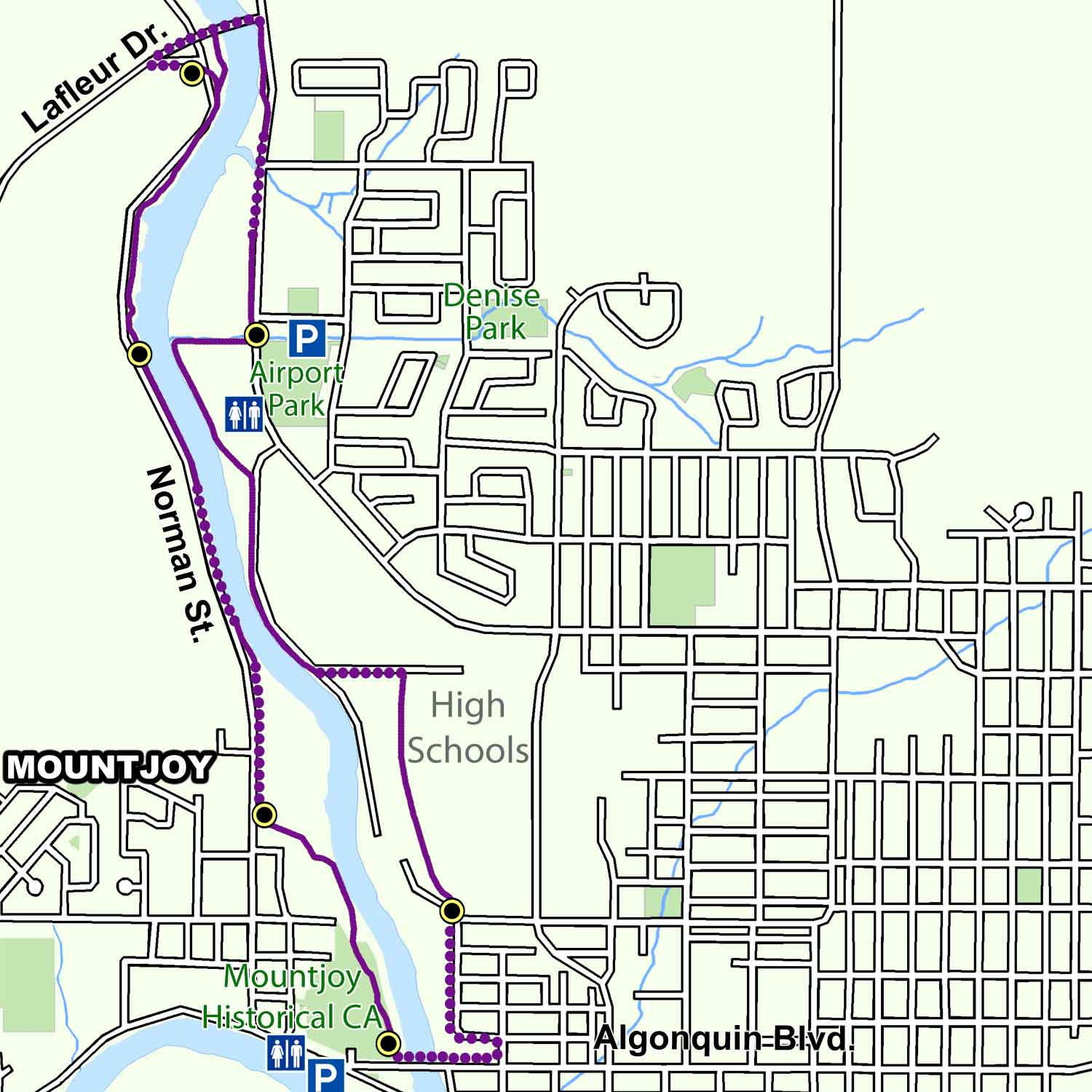
The Bridge to Bridge Trail runs along both banks of the Mattagami River between Algonquin Boulevard and Lafleur Drive. It connects to the Waterfront Trail at the Mattagami boat launch and the Scout Rock Trail through Denise Park. It is a total of 7 km in length and offers scenic views of the Mattagami River and the many natural features that can be found along its shores.
Trail Description
Mattagami Heights is the trail head of the Bridge to Bridge Trail and is the Mountjoy Historical Conservation Area. Heading north along the Richelieu Promenade and the shores of the river, the trail emerges at Norman Street where is makes a turn to the right. Continuing along Norman Street, the trail cuts in and out of the bush along the way. At Place Richelieu a set of stairs takes the trail to the top of the bridge and over to the east side of the river. The trail then makes another right turn and heads south to the Airport Road Crossing. It is here that the Marcel Lafleur Rotary Walk starts. The trail follows along a fence and to the shores of the Mattagami River. Once it reaches McChesney Road, it continues south to Auxilia Avenue and then towards the high schools. Starting at the back gate, the trail swings to the right and south again, at which point it reaches the Domtar Overlook. Continuing on, it passes in front of Interfor’s (previously Eacom Timber) main gate and along to the far end of Gillies Street, left on Poplar Avenue, right on Fogg Street, right on Algonquin Boulevard and crossing the bridge, you return to the starting point at Mattagami Heights.
Terrain: Generally flat with a set of stairs to climb and a downward sloping hill.
Highlights
- Along the west bank of the Mattagami River, you will find the Mountjoy Historical Conservation Area. The large park area was developed by the Conservation Authority through a flood plain land clearance project undertaken in the early 1970’s. Over 60 homes and several businesses were either removed or demolished. The Eacom mill can be seen across the river. Many years ago, springtime log drives brought large log booms of spruce, pine and fir to this location for processing in the many mills that dotted along the shoreline.
- Norman North sits on an old hydro line right-of-way that once connected the Sandy Falls Generating Station to the downtown area with 25-cycle power. Up until the 1960’s, Timmins, including all the local mines, ran off 25-cycle instead of the usual 60-cycle power grid.
- The Cedar Meadows landing offers a variety of wildlife viewing opportunities as well as a good place to catch some fish. This section of trail highlights some of the added features you will see next to the trail including an osprey platform across the river next to the sewage treatment plant, and several duck nesting boxes along the shoreline.
- The trail’s halfway point is marked by Place Richelieu and the Lafleur Drive bridge. Make a side trip across Norman Street at this point an you might see a number of different animals in the Cedar Meadows Resort compound including bison, elk and a variety of deer.
- After following Airport Road to the south you will reach the Airport Road Crossing where you can turn right to continue along the Bridge to Bridge Trail or left towards Denise Park and the Scout Rock Trail. The Crossing also marks the start of the Marcel Lafleur Walk with its osprey platform, benches, storyboards and shelter.
- The last stop along the trail is the Domtar Overlook located high above the Interfor (Eacom) sawmill. From this point, you can see the entire process of turning harvested trees into kiln dried finished lumber. This location also offers a great view of the western horizon including Mount Jamieson (Kamiskotia Snow Resort) and the Mattagami River.
- Just as the main trail reaches back to the Mattagami Heights, a section of it crosses beneath the Mattagami Bridge and over to the Mattagami boat launch.
Trail Maps
Georeferenced maps are available to download on our trail maps page. Pocket maps are available at the MRCA office.