Alert
This trail is not maintained between November 1 and April 30.
Please respect the Porcupine Ski Runners volunteers and do not walk or cycle on these groomed trails during the winter months.
The 8.5 km Rotary Trail connecting Schumacher and South Porcupine was developed with the support of the Porcupine and Timmins Rotary Clubs and features many interesting natural and historic highlights. It uses part of the old ONR right-of-way, sections of the Porcupine Ski Runners trail system and a large tailings dam. It traverses a very rolling topography with several steep inclines, water crossings, bedrock outcrops and extensive marshes. The Rotary Trail is a key connecting link that literally brings the east and west ends of the community together.
Trail Description
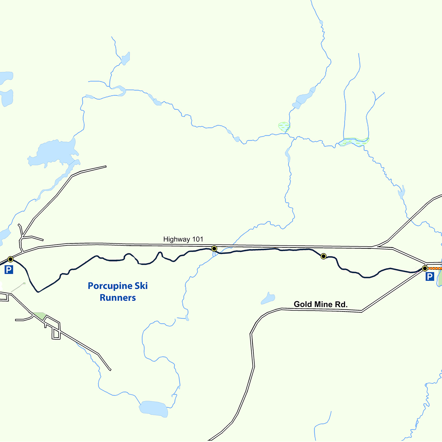
Just outside Schumacher on your way to South Porcupine is a small parking area on the south side of Highway 101. This, for the time being, is the trailhead and the start of the Rotary Trail. It goes by the name of Schumacher Heights. As you descend onto the abandoned ONR right-of-way, the trail quickly turns onto the Ski Runners track where it continues for 3 km along side a broad wood chip trail. For a good part of this section you will be following a hydro line and ascending and descending several hills. About 2 km along, the trail takes a sharp right turn at the top of a steep hill and heads due east. You will notice that there are many different trails one can take so be sure to stay on the hard packed granular surface. If you feel a little adventurous try some of the different loops the Ski Runners offers. Use the many directional signs beside the trail to find exactly where you are going. You will notice that shortly after your right hand turn the granular trail will leave the wood chips and start following its own right-of-way. After another short distance you will again pick up the Ski Runners trail, ascend a steep rock outcrop, pass under two major powerlines and emerge close to Highway 101 and a small parking area. This is the midway point of the trail.
Carrying on eastward, the trail comes to Porcupine Creek where it crosses a large pond and a stream. From here it slowly rises up onto a tailings dam constructed as part of the Newmont mine operations. This 2 km section of trail is relatively flat and has several interesting overlooks. The last section of the trail starts at the Dome Terraces where it descends from the tailings into the forest. It is probably the most “wild” portion but travel is easy with few hills and wide curves. The last kilometre of trail again joins in with the Ski Runners. A steep hill near the end brings you down by the Back Road and Spruce Hill. From here it is only a short distance to downtown South Porcupine.
Highlights
- Schumacher Heights marks the start of the Rotary Trail. This trail uses the former ONR right-of-way, abandoned in the late 1980’s when train travel into Timmins proved uneconomical and room was needed for the expansion of Highway 101. From here, one quickly moves into the Porcupine Ski Runners facility. This cross-country ski club opened its doors back in 1973 and now boasts over 30 km of groomed trails, some of which are lit for night time use.
- Much of the Rotary Trail is located in an area of thin soils, bedrock outcrops and a variety of upland and lowland terrain. In sharp contrast to the Golden Springs Trail where glacial sands and gravels are dominant, this trail offers an entirely different environment. Balsam fir, black spruce along with poplar and white birch are the dominant tree species. There are also a variety of plants and animals unique to this environment of wet ground and thin soil. Do not be surprised if you see the occasional red fox, moose or, if you are really lucky, lynx.
- After leaving the Ski Runners trails, one crosses several utility corridors used for hydro and natural gas. Although much of this energy is destined for the Timmins market, the substantial Hydro KV lines are an important link between northern and southern Ontario transferring power from the large Abitibi Canyon facilities to southern markets. Another interesting aspect of this section of trail is that just to the north are the remnants of the old Ferguson Highway, the first permanent road link into the Porcupine Camp. It was eventually replaced by Highway 101.
- The Porcupine Crossing involves a tributary of the North Porcupine River. This crossing includes both a causeway and a wooden bridge. A rest area has been constructed next to the creek. It is here one can see dam building at its best, one by the hand of nature and the other by the hand of man. This narrow portion of the creek offers local beavers an excellent opportunity to partially block the flow of water in order to create a pond for their lodge and feed bed. The steep slope beyond this dam is the first level of a Newmont Goldcorp impoundment used to contain tailings left over from the processing of gold ore. Constructed some time in the 1940ís, this large tailings dam has been given a lot of attention to ensure that stabilizing trees, shrubs and a variety of grasses will grow. Different species and special fertilizers have been selected to make sure the plants survive in this harsh, sterile environment.
- As the trail rises from the marsh lowland and onto the tailings dam, one gets a great view of the entire area including the extensive flood plain of the Porcupine River, the Tisdale Cemetery and the massive Newmont Goldcorp tailings dam.
- From the far east end of the dam at the Dome Terraces, the trail quickly descends into the forest where it winds its way through stands of mature poplar and balsam. As the trail emerges at Spruce Hill in South Porcupine, a steep hill and a large dome of bedrock will greet you. A little to the north this same bedrock outcropping has visible quartz veins, often a sign gold deposits are nearby.
- The final stretch of trail takes you to the “Y” and the community of South Porcupine beyond. It is interesting to note that not too long ago Dome Mines built and maintained a trail/sidewalk along this same stretch for their workers travelling from South Porcupine.
Trail Maps
Georeferenced maps are available to download on our trail maps page. Pocket maps are available at the MRCA office.