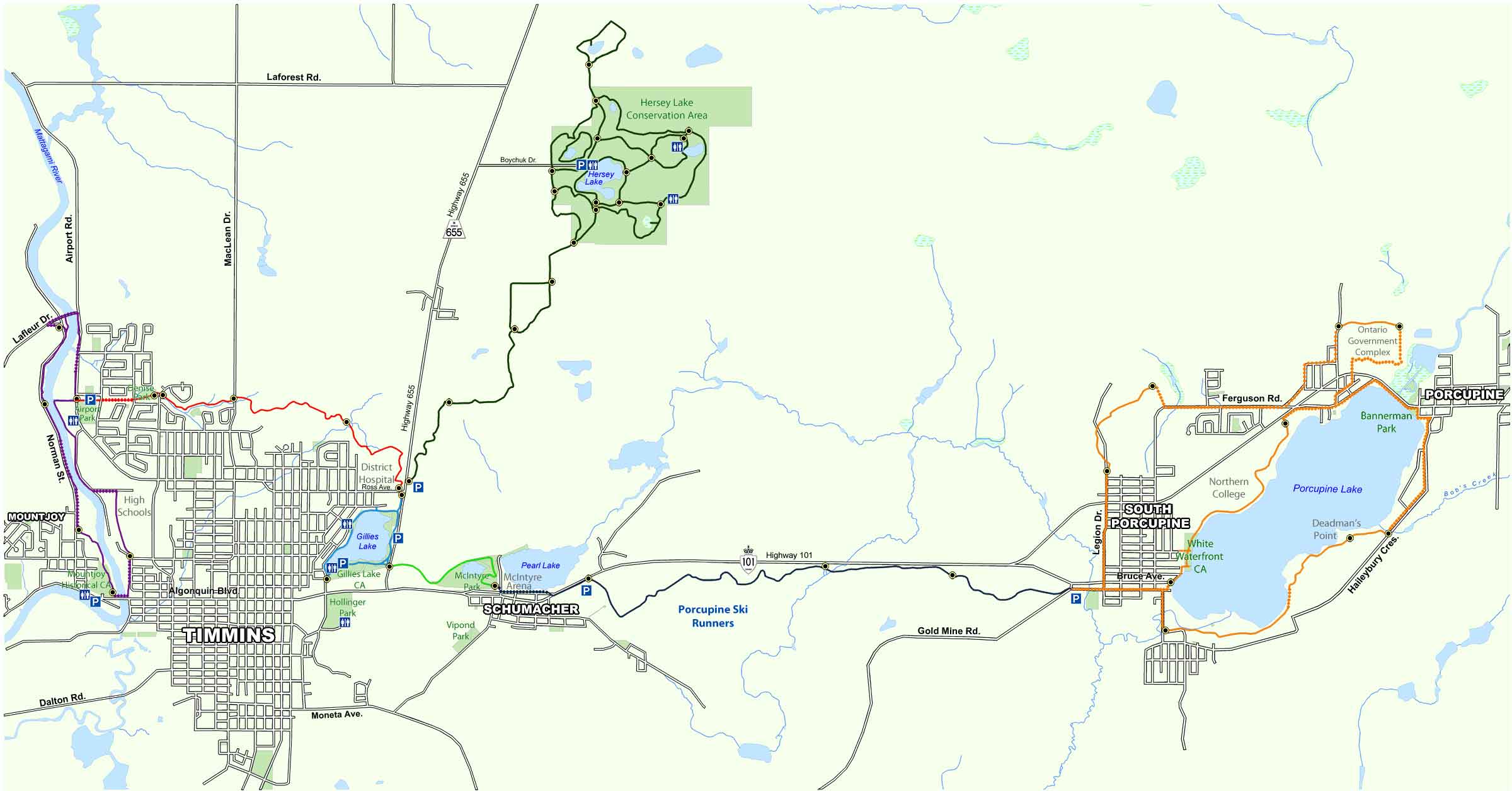
Whether you are walking or cycling, nature trails provide convenient and safe access to the great outdoors in and around the City of Timmins. With a hard packed rock surface, the 55 km recreational trail system reaches to the four corners of the community, connecting the major conservation areas and many points in between. If you want to enjoy the popular walking oval at Gillies Lake, the wilderness trails at Hersey Lake or scenic strolls around Porcupine Lake, the trails are excellent for hiking, cycling, cross country skiing, snowshoeing, and nature appreciation. Rest areas, scenic lookouts and interpretive signs are a few of our trail features. Motorized vehicles, including ATVs, dirt bikes, and snowmobiles are not allowed on the recreation trail system.
Georeferenced maps are available to download on our trail maps page. Pocket maps are available at the MRCA office.
The Bridge to Bridge Trail follows along both banks of the Mattagami River between Algonquin Boulevard and Lafleur Drive. See our Bridge to Bridge Trail page for more information about this section of the trail.
The Scout Rock Trail connects with the Gillies Lake Promenade and Golden Springs Trail at the corner of Hwy 655 and Ross Avenue East. It continues on to Denise Park, providing easy access to the entire trail system for those living in the north end of the city. See our Scout Rock Trail page for more information.
The Golden Springs Trail links the Gillies Lake Conservation Area and the Hersey Lake Conservation Area. More information about this trail can be found on our Golden Springs Trail page.
The trail system in our Hersey Lake Conservation Area includes the Hersey Lake Promenade and several interconnecting inner loops and roadways. It features a self-guided interpretive Tamarack Trail and directional distance signage so you will know exactly where you are. See our Hersey Lake Trail and Tamarack Trail pages for more information.
The Gillies Lake Promenade links the Scout Rock, Golden Springs and Lion’s Walk Trails. This is one on the most popular trails and is contained entirely on Conservation Area property. As such, we are able to offer winter grooming on this trail for winter walkers. Lighting is also provided for evening use. More information can be found on our Gillies Lake Promenade page.
The first phase of the McIntyre Park revitalization was the creation of the Lion’s Walk between the Gillies Lake Promenade and the Rotary Trail in Schumacher. It provides an ideal loop between Timmins and Schumacher. See our Lion’s Walk page for information about the trail highlights.
The Rotary Trail is one of most recent trail additions and is a key connecting link between the east and west ends of the community. Developed with support from the Porcupine and Timmins Rotary Clubs, its links the Lion’s Walk and the Bart Thomson Trail in South Porcupine. Our Rotary Trail page will provide you with details of this trail.
Named after on of the founding members of the Trails Committee, the Bart Thomson Trail encompasses the shoreline of Porcupine Lake and an area to the north of Porcupine and South Porcupine. From the trail, you can access the shoreline of Porcupine Lake at several locations. This trail consists of a north loop and a south loop. See the Bart Thomson Trail page for information about the trails.